

Project: Hand-Drawn Map of London
Design & Illustration: Jitesh Patel
Location: London, UK
Category: Map Illustration, Cityscape, Editorial


Overview
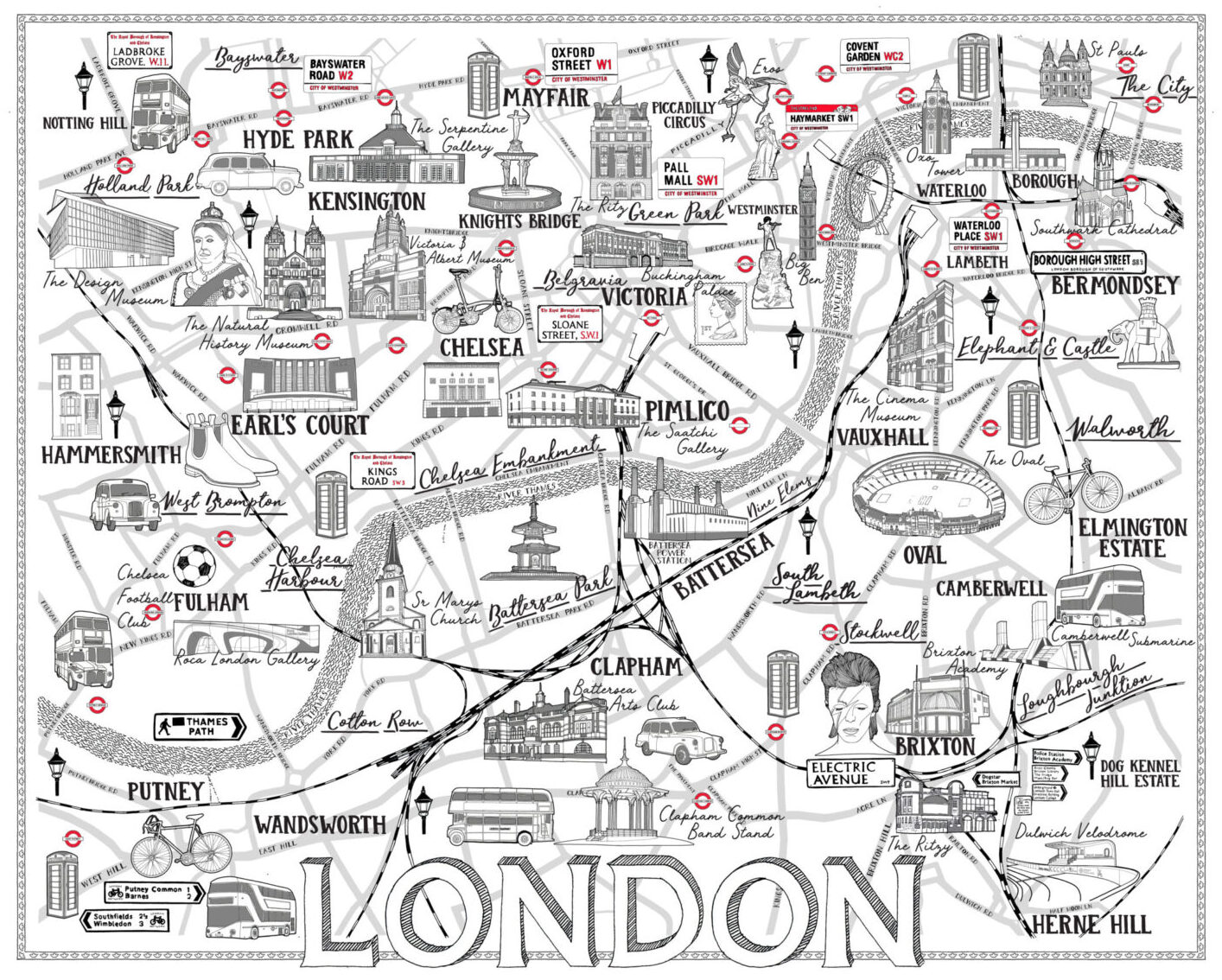
This self-initiated hand-drawn map of London celebrates the city’s rich geography, architectural icons, and lesser-known gems through a meticulously illustrated black-and-white composition. Designed to spark curiosity and admiration, the piece is both a visual exploration and an artistic tribute to London’s layered identity.
Approach
The concept was to create a detailed yet navigable map that fused London’s familiar landmarks with its overlooked treasures. Rather than focusing purely on geography, the illustration was designed to reflect the city’s personality through a stylised, typographic approach. Scripted labels and flowing lines form the foundation, enhancing readability while adding a handcrafted aesthetic.
The journey begins in North West London’s Holland Park, meandering through Putney in the south-west, passing through the leafy streets of East Dulwich, and culminating in Central London’s Financial District. The River Thames acts as a central anchor, weaving its way through the map to unify the diverse locations.
Design Details
Iconic London landmarks are featured prominently, including:
-
The London Eye
-
Battersea Power Station
-
Brixton Academy
-
Victoria & Albert Museum
-
Buckingham Palace
-
Tate Modern
-
St. Paul’s Cathedral
To balance the well-known with the unexpected, the map also highlights unique local landmarks such as:
-
Dulwich Velodrome
-
Elephant and Castle statue
-
Camberwell Submarine
-
Clapham Common Bandstand
-
St. Mary’s Church, Battersea
Each element is illustrated with precision, supported by flowing hand-drawn type to label boroughs, neighbourhoods, and points of interest. The use of monochrome allows the details and linework to take centre stage, offering clarity and sophistication.
Outcome
The final artwork serves as both a decorative print and a functional city guide, inviting viewers to experience London through a new lens. Its visual storytelling brings together the capital’s grand icons and hyperlocal charm, offering an engaging alternative to traditional maps.
This map has been exhibited, licensed for editorial use, and purchased as a fine art print—reflecting its broad appeal to design lovers, Londoners, and travellers alike.


