

Client: Ink Global
Commissioned by: Brussels Inflight Magazine
Design & Illustration: Jitesh Patel
Location: Northern Ireland
Category: Illustrated Map
Overview
I was commissioned by Ink Global to create an illustrated map of Northern Ireland for Brussels Airline’s inflight magazine. Ink Global produces award-winning media and content for passengers worldwide, creating over 25 magazines in eight languages for airlines including American Airlines, United, Iberia, Airberlin, Norwegian, and Scoot, as well as selling digital media space for KLM, EasyJet, Aer Lingus, Cebu Pacific, and more.
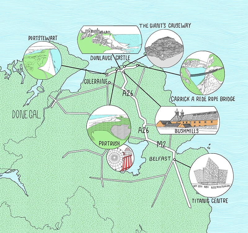
The map highlights key points of interest across Northern Ireland, including Belfast’s Titanic Centre, Bushmills Distillery, The Giant’s Causeway, Carrick-a-Rede Rope Bridge, Portrush, Portstewart, and Dunluce Castle.
Approach
Stylistically, this project presented a unique challenge. In my previous illustrated maps, I placed locations directly onto the map layout. For Northern Ireland, the magazine’s dimensions made it difficult to fit all locations without overcrowding the composition. To resolve this, I introduced floating image bubbles, cropping the spot illustrations and positioning them strategically across the layout. This solution maintained clarity without compromising the overall design.
The map was developed in individual sections. I began by drawing the road networks separately, which provided the underlying structure for the composition. Next, the spot illustrations were rendered using a fine liner ink Rotring pen and placed onto the road layout. Once the visual composition was established, I added hand-rendered typography, placing location names beneath each illustration to integrate seamlessly with the map.
Design Details
Illustration Medium: Fine liner ink (Rotring pen) on paper
Layout Solution: Floating image bubbles to accommodate multiple points of interest within magazine dimensions
Composition: Roads drawn first, followed by placement of spot illustrations
Typography: Hand-rendered font for location names, integrated into the illustration
Style Consideration: Balanced clarity and visual appeal, ensuring legibility while maintaining an engaging artistic style
Outcome
The final illustrated map offered travelers a visually engaging guide to Northern Ireland, blending practical navigation with artistic interpretation. The floating image bubble technique allowed each location to be showcased prominently while keeping the map clean, readable, and aesthetically pleasing for inflight publication.


